 A new digital, interactive map documenting Germany’s geothermal energy potential, and possible locations, has been released.
The resource was developed through the WärmeGut research project under the direction of the LIAG Institute for Applied Geophysics (LIAG) in Hanover, with the Georg-August-University Göttingen (UGOE) and the company, geoENERGIE Konzept GmbH from Freiberg, in collaboration with all 16 geological state services.
It is now freely available in the Geothermal Information System GeotIS.
The project’s manager, Prof. Dr. Inga Moeck, hailed it as a “historic milestone” for geothermal research in Germany.
"Together with the project partners and the state geological services, we have succeeded in developing a digital map that meets both the individual requirements of the respective federal states and an easy-to-understand standardisation of the complex data situation.”
The Federal Ministry for Economic Affairs and Energy (BMWE) provided funding the project.
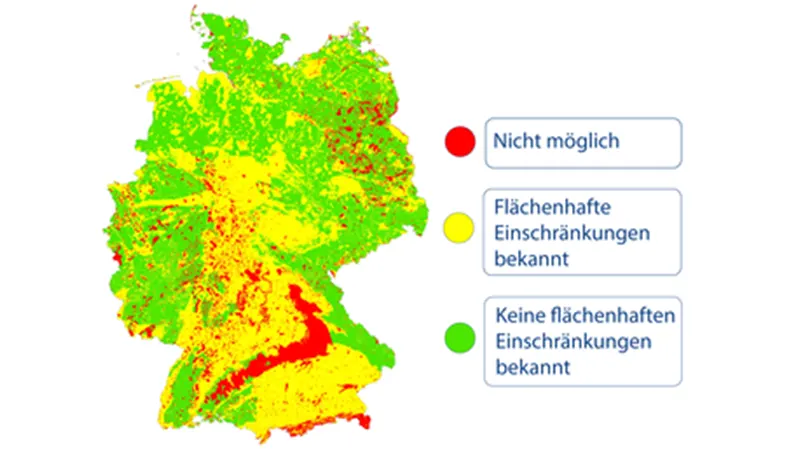
The map is based on a traffic light system with ‘green’ showing regions where geothermal probes can be used without restriction, yellow indicating limited usage opportunities, and red highlighting areas that are not eligible for use.
This simple system is intended to offer both specialist companies and private homeowners and municipalities a quick entry into geothermal energy and an uncomplicated orientation as to whether geothermal use is possible by means of probes or not.
The researchers expect the interactive map to grow interest in geothermal across the country and to help municipalities, cities and even households understand potential use cases and opportunties.
“Without geothermal energy, the [energy] transition cannot succeed,” said Moeck.
“We expect that this map will draw attention to geothermal energy as a measure in municipal heating planning and give a decisive boost to both the energy transition and scientific geothermal research.”